![]()
![]()
![]()
![]()


|
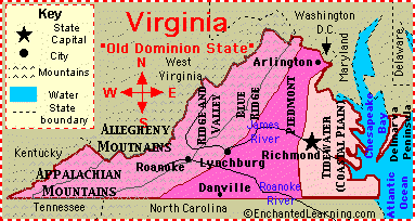
| For readers who wonder what we research and why we care, the below extract and site is recommended for gazing at the sites and sounds of ancestors who worked in the mines, mills, foundries, boat-yards, construction industries and all the other skilled and non-skilled requirements for labor in developing wealth in the State of Virginia. One can not know much about their ancestors there or anywhere without understanding the geography that bound them to men who mastered lands, lakes, mountains, rivers, and valleys.
It will also help gain admiration and even more respect for men like Washington and Jefferson, among thousands of other men of the great English heritage, ... curiosity about geography and the thrill of exploration beyond their comfort zone and eyesight. For men of their generations, learning geography and the skills of a land surveyor was a fundamental requirement for educating boys to be men of means that matter, ... property acquisition and ownership. Most slaves had little or no knowledge of geography and were intentionally kept ignorant of it less they be tempted to run away, ... knowing north, south, east, west, etc. necessary to navigate themselves to liberty. Indeed, most slaves would spend their lives toiling the land and creating wealth for others. Not the least of these wealth creation labors was that of giving birth to new generations of slaves, making slave breeding Virginia's largest and most profitable industry by beginning of the Civil War. The extract also refutes the notion that slavery was dying out in Virginia or anywhere else, and indeed was steadily increasing. http://www.newrivernotes.com/va/vagaz1854.htm#gaz Statistical Gazetteer of the State of VirginiaEmbracing important topographical and historical information from recent and original sources, together with the results of the last census population, in most cases to 1854 By Richard Edwards "The Meherrin and Nottoway are small rivers, which unite in North Carolina, and form the Chowan. The Roanoke is formed in Virginia by the junction of Dan River and Staunton River, two rapid mountain streams which rise, the former in the Blue Ridge, and the latter in the North Mountain. The larger part of the Roanoke is through North Carolina, which State it enters about 40 miles below the union of its constituent rivers. The great rivers of Western Virginia, flowing to the Ohio River, are-the Monongahela, one of the constituents of that river; the Kanawha; the Guyandotte; the Big Sandy, &c. The Monongahela is formed in Virginia by the junction of the West Branch and Tygart's Valley River, and beyond the Pennsylvania line it receives Cheat River, which descends from Greenbrier Mountain, and which is navigable for boats for a considerable distance. Little Kanawha River rises in the same district with the west branch of Monongahela River, and enters the Ohio at Parkersburg. The Kanawha, the principal river of Western Virginia, rises in the Blue Ridge, in North Carolina, and bears the name of New River until it unites with Gauley River, a small affluent from Greenbrier Mountain. The Greenbrier, above the latter, and the Elk and Coal rivers below it, are its principal tributaries. It is navigated by steamboats to Field's Creek, 75 miles from its mouth. The Covington and Ohio Railroad, and the James River and Kanawha Canal traverse the valley of this river. The Guyandotte and Big Sandy enter the Ohio below the Kanawha-the latter forming part of the boundary between Kentucky and Virginia. The Holston and Clinch, which drain the south-western section of the Great Valley of Virginia, pass into Tennessee, and, uniting at Kingston in that State, form the Tennessee River. Virginia is an almost boundless field of mineral wealth, and within its limits, not only the useful, but also the precious metals are found in one part or the other. Gold, copper, lead, iron, coal, salt, lime, marls, gypsum, magnesian and alum earths, marbles, granites, soap-stones, and sand-stones are among the treasures, as yet for the most part lying unheeded in the bowels of the earth. Mining industry, however, has been commenced, and within the past few years has been wonderfully developed. The first coal-field is found at the junction of the Tide-Water and Piedmont sections; and this extends from the Pamunky by Richmond to the Appomattox, a distance of about thirty-five miles, with a breadth of from one or two to eight miles. The coal is bituminous, in seams of enormous thickness, being 30, 40, and even 60 feet thick, and of excellent quality. Coal has also been found on both sides of the Upper Appomattox. The following table will show the decimal progress of the population since the first census of the State, taken by the United States authorities.
The aggregate statistics of the resources, wealth, productions, manufactures and institutions of the State, according to the census of 1850, and other official returns referring to the same period of time, are as exhibited in the following summary: Occupied Lands, etc.--Improved farm lands, 10,361,155 acres, and unimproved lands, 15,792,176 acres- valued in cash at $216,401,441. Tile whole number of farms under cultivation on the 1st of June, 1850, was 77,013-in the Eastern District, 87,741, and in the Western District 39,272. Value of farming implements and machinery, $7,021,772. Live-Stock.-Horses, 272,403; asses and mules, 21,480; milk cows, 317,619; working-oxen, 89,513; other cattle, 669,137; sheep, 1,310,004; and swine, 1,830,743. The live-stock of 1840, and the comparison of that with the live-stock of 1850, exhibit the following results:
In 1850 the total value of live-stock was estimated at $33,656,659. Products of Animals.-Wool, 2,860,765 pounds; butter, 11,089,359 pounds; cheese, 436,298 pounds; and the value of animals slaughtered during the year was $7,503,006. The wool crop accounted for in the census of 1840 amounted to 2,538,374 pounds; and hence the increase in the crop of 1850 was 322,391 pounds, or in the ratio of 12.7 per centum. In 1840 tile average clip per fleece was 31.4 ounces, and in 1850, 34.9 ounces, making, an increase in 1850 of 3.9 ounces per fleece, or 12.4 per centum. Grain Crops.-Wheat, 11,232,616 bushels; rye, 458,930 bushels; Indian corn, 35,254,319 bushels; oats, 10,179,045 bushels; barley, 25,437 bushels; and buckwheat, 214,898 bushels. The several yields compared with those returned in the census of 1840 give the following results:
Other Food Crops.-Rice, 17,154 (in 1840, 2,596) pounds; peas and beans, 521,581 bus.; potatoes-Irish, 1,316,933 bus., and sweet, 1,813,671 bushels. The potato crop of the census of 1840 amounted to 2,944,660 bushels, and hence the increase in 1850 is 185,944 bushels, or at the rate of 6.3 per centum. Miscellaneous Crops.-Tobacco, 56,803,218 pounds; cotton, 3,947 bales of 400 pounds; hay, 369,098 tons; clover-seed, 29,727 bushels; other grass seed, 23,428 bushels; hops, 11,506 pounds; hemp-dew- rotted 90 tons, and water-rotted 51 tons; flax, 999,450 pounds; flax-seed, 52,318 bushels; silk cocoons, 517 pounds; maple-sugar, 1,227,665 pounds; molasses, 40;322 gallons; beeswax and honey, 880,767 pounds; wine, 5,408 gallons, etc. The value of orchard products $177,137, and of market-garden products $183,047. The principal crops exhibited in the censuses of 1840 and 1850 are comparatively as follows:
The coal of the Richmond basin is now extensively mined, and a railway to the principal mines has been built to facilitate its transportation to tide-water. Anthracite of great purity is found in the valley from the Potomac to the James River, south of which it contains a considerable portion of bitumen. Beyond the Allegahanies there are some of the most extensive and valuable deposits of bituminous coal in the United States, which derive additional value from their being associated with not less important beds of iron and salt. At Wheeling, on the Ohio, and for fourteen miles down the river, the bank presents an uninterrupted bed of highly bituminous coal, upward; of 16 feet thick. The Wheeling basin, indeed, extends for 30 miles up and down the river in Ohio and Virginia. Another vast field stretches above Clarksburg, on. the Monongahala to Pittsburg, and far beyond to the north-east in Pennsylvania. There is also a valuable coal-field on the head- waters of the north branch of the Potomac. Thus we have five tiers of coal seams, with an average thickness of from 30 to 35 feet. There are also coal seams associated with salt springs on the Little Kanawha, and springs of petroleum, or rock oil, occur in the same tract. On the Great Kanawha is also a very rich and extensive coalfield: and on Coal, Gauley, and other rivers in this portion of Western Virginia, the beds of this mineral are frequently brought to view, and in fact no better general description can be presented of its extent than that it is almost continuous with the vast beds of sandstone which spread in nearly horizontal planes over nearly the whole of this broad region. The salines of Virginia are almost wholly in the west. Salt springs occur on the Holston, on the New River, and on the Greenbrier; but the most important works are on the Great and Little Kanawha rivers. The brine is raised by steam power, and evaporated in large cast-iron pans over furnaces. The brine of the Kanawha wells contains very little gypsum or sulphuret of lime, and the process of crystallization is therefore attended with fewer difficulties than usual. The average yield of salt is about one bushel from every 65 or 70 gallons of brine." [Richard Edwards} | ||||||||||||||||||||||||||||||||||||||||||||||||||||||||||||||||||||||||||||||||||||||||||||||||||||||||||||||||||||||||||||||||||||||||||||||||||||||||||||
Email: Editors, More Mary Matters bradyenterpriseassociation@gmail.comwith questions or comments about this web site. |